Que Tal? This is an expressions that means, "what´s up" or "how´s it going?"
I am finally feeling better but being sick for so long left me feeling a little weak so sadly Nathan and I were not able to do our trek to the volcano. We are now in Junin de los Andes, Argentina where Nathan is doing a lot of fly fishing.
I am finally feeling better but being sick for so long left me feeling a little weak so sadly Nathan and I were not able to do our trek to the volcano. We are now in Junin de los Andes, Argentina where Nathan is doing a lot of fly fishing.
As we walk around different towns here in South America we see a lot of stores selling various things. Usually a tienda, or shop, will sell only one or a few kinds of things. This is unlike many stores in the United States which sell almost everything you might need in one place, like WalMart or KMart. But here larger stores like those are less common.
There is something else different about the tiendas here as well. In the middle of the day they will usually close for siesta, or afternoon break. In fact, everyone takes a siesta from around 1 or 2 in the afternoon until 5 or 6 in the evening. Schools, work places, stores, just about everything shuts down for a few hours while people go home to have a large meal with their families and maybe take a nap. Afterwards they return to school or work until about 8 in the evening. This means that dinner is very late, usually not until 10 o´clock at night!
As I said earlier, the small tiendas usually sell just a few kinds of things. Their names usually include the word for the goods they sell and end in the suffix -eria. For example, the word for bread is pan, and a store that sells bread is a panaderia.

Do you think you can figure out what these stores sell in the pictures below? I´ll get you started by giving you the spanish root words for the goods being sold, then you try to find which stores sell these things. There are some good hints in the pictures themselves. Below the pictures are the answers--but don´t peek until you´ve tried!
libro = book
joyas = jewelry
sombrero = hat
reloj = watch
zapatos = shoes
pelo = hair
flor = flower
lavar = to wash


ANSWERS
peluqueria: a hair parlor (not a store that sells pelo, or hair, but one that cuts hair!)
lavanderia: a laundromat, a place for lavar, or washing, clothes libreria: sells libros, or books
floreria: sells flores, or flowers
joyeria and relojeria: sells joyas, or jewelry, and relojes, or watches
zapateria: sells zapatos, or shoes
 So you see, travelling is not all fun and games! Getting sick, long bus rides, difficulty in finding places to stay, waiting for transportation and all kinds of other things happen, but as long as we keep a good attitude and stay positive we get through it and still have fun!
 The meat and milk from cows are also very important to the economy of this region. The
 We spent 8 days hiking across the island from the north to the south. A trail begins just outside the small town of

 Eventually we made our way down to a
 After the trip to the bay we took a few more days to walk back north to Puerto Williams. We passed through more peat bogs, mountains, and lots of beaver ponds, too. Beavers were introduced to Isla Navarino many years ago in hopes of creating a fur trade. But the idea was abandoned and now the beavers have flourished and caused a lot of destruction. They are not native to the island so their activities hurt the wildlife and plants that grow there naturally.

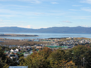 Because Antarctica is the next closest landmass, many people travel to Ushuaia to sail their boats from here to Antarctica. Like Darwin and Fitz Roy were, they are true adventurers, having to brave rough seas, cold temperatures and rocky coasts, but they also see amazing things, too. Penguins, sea lions, whales, albatross and other marine wildlife are common, as are amazing landscapes covered in ice and snow.
  As you might guess, since we are so far south and that close to Antarctica, the weather here is getting quite chilly! March is the beginning of autumn here in the southern hemisphere (remember that the seasons here are opposite ours) and the first snows have fallen on the jagged peaks we see around Ushuaia. It´s time to head north soon!